Location
Hardin County, TN
Coordinates
35.0318°N, 88.1317°W
Trail Rating
Tech 5 — Moderate Difficulty
Trail Length
6.9 miles (Rainbow Falls Loop)
Best Seasons
Spring, Summer, Fall
Directions
Getting to Rainbow Falls
From Savannah, TN
- 1Head south on US-64 W / TN-128 S toward Pickwick Dam
- 2Turn right onto Dry Creek Road
- 3Follow Dry Creek Road to the OHV staging area
- 4From the staging area, take the Rainbow Falls Loop trail (6.9 miles)
- 5The falls are located approximately 3.5 miles into the loop
From Memphis, TN
- 1Take I-40 E to US-70 E toward Jackson, TN (approx. 80 miles)
- 2Continue on US-70 E to Savannah, TN (approx. 60 more miles)
- 3In Savannah, take TN-128 S toward Pickwick
- 4Turn right onto Dry Creek Road to the OHV staging area
- 5Total drive time: approximately 2.5 hours from Memphis
Trail Details
Rainbow Falls Loop
Distance
6.9 miles
Full loop
Difficulty
Tech 5
Moderate — suitable for stock 4x4 with clearance
Elevation
162 m
Gain over the loop
Vehicle Width
Up to 50"
Standard SxS width
Surface
Dirt, rock, creek
Water crossings present
Season
Year-round
Best spring through fall
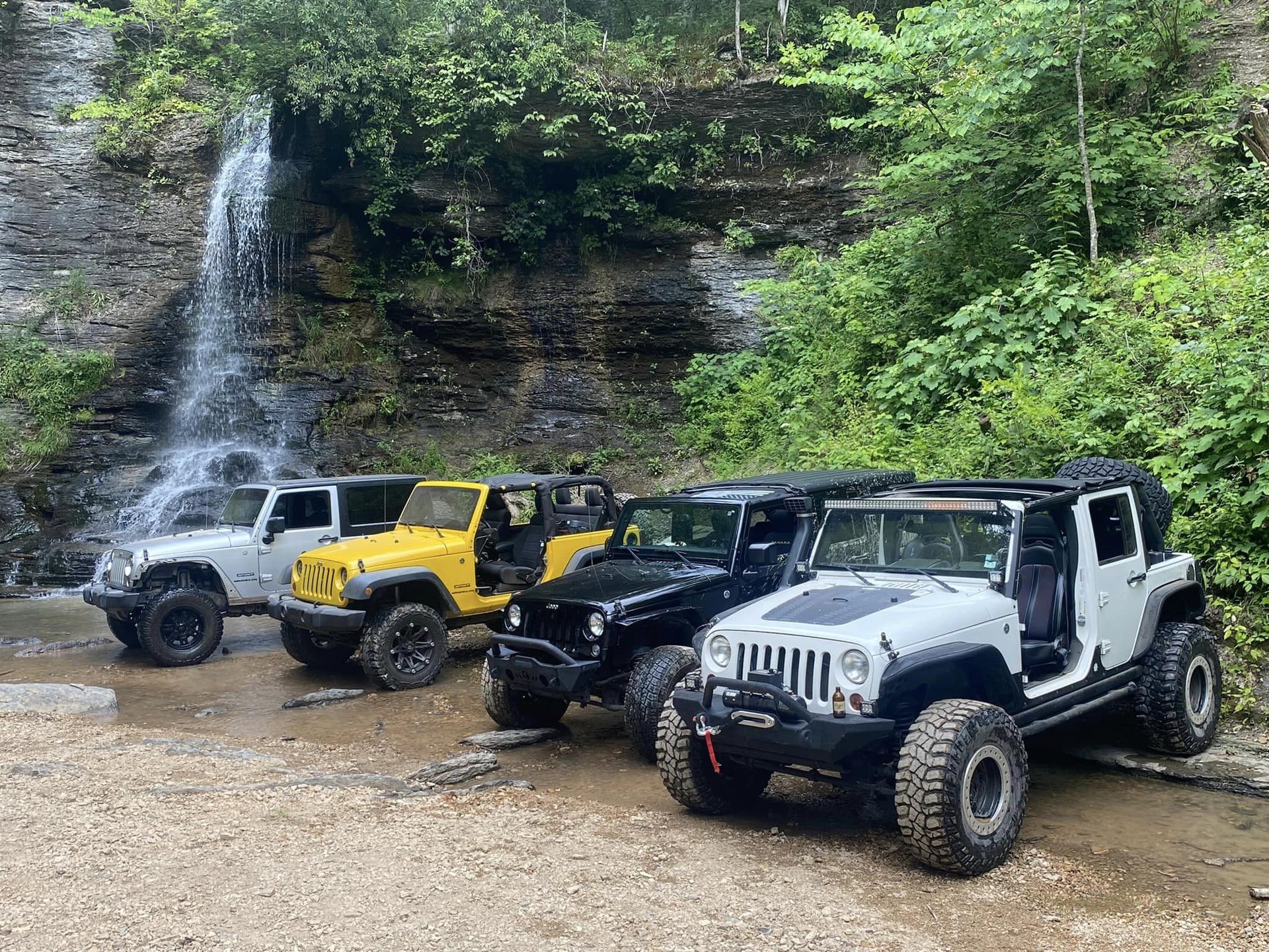
The Rainbow Falls Loop is a 6.9-mile off-road trail that winds through the Dry Creek OHV area of Hardin County, Tennessee. The trail is rated Tech 5 (Moderate) and is suitable for stock 4x4 vehicles with adequate ground clearance, as well as ATVs and side-by-sides up to 50 inches wide.
The trail features multiple creek crossings, rocky sections, and muddy stretches depending on recent rainfall. The terrain is characteristic of the Tennessee hill country — limestone outcroppings, dense hardwood forest, and clear-running creeks. The highlight of the loop is Rainbow Falls itself, a dramatic waterfall that tumbles over layered limestone ledges into a clear pool below.
Hikers are welcome on the trail system as well. The walk to Rainbow Falls is approximately 3–4 miles one way from the main staging area, depending on the route taken. Wear sturdy waterproof footwear, as creek crossings are unavoidable on foot.
When to Go
Seasonal Conditions
Spring
March – May
Water Level: High
Best waterfall flow after winter rains. Trails may be muddy. Wildflowers bloom along the creek. Temperatures mild (50–70°F).
Summer
June – August
Water Level: Moderate
Hot and humid (80–95°F). Creek crossings are refreshing. Lush green canopy provides shade. Bring plenty of water.
Autumn
Sept – November
Water Level: Low–Moderate
Spectacular fall foliage. Cooler temperatures (45–70°F). Lower water levels reveal more rock formations. Best photography season.
Winter
Dec – February
Water Level: Variable
Cold (25–50°F). Trails less crowded. Ice formations possible on the falls. Bare trees open up views. Occasional trail closures after snow/ice.
Be Prepared
Tips for Your Visit
Vehicle Prep
- Ensure your vehicle has adequate ground clearance (minimum 8" recommended)
- Check tire pressure before entering — aired-down tires improve traction on rocks
- Carry a recovery strap, hi-lift jack, and basic tool kit
- A winch is recommended but not required for Tech 5 terrain
- Bring extra fuel — the nearest gas station is in Savannah or Counce
Trail Etiquette
- Yield to uphill traffic on single-track sections
- Pack out all trash — leave no trace
- Stay on marked trails; avoid creating new tracks
- Respect private property boundaries
- Do not disturb the waterfall area — no cliff jumping
Safety
- Cell service is limited in the Dry Creek area — download offline maps
- Tell someone your plans and expected return time
- Carry plenty of water — at least 2 liters per person
- First aid kit and emergency blanket are recommended
- Be aware of weather — flash flooding can occur in creek bottoms
While You're Here
Nearby Attractions
Pickwick Lake
Recreation~10 miles
One of Tennessee's premier fishing and boating lakes, created by TVA's Pickwick Landing Dam in the 1930s. World-class bass, crappie, and catfish fishing.
Shiloh National Military Park
History~15 miles south
Site of the bloody April 1862 Civil War battle. The park preserves the battlefield where nearly 24,000 men were killed, wounded, or went missing in two days.
Pickwick Landing State Park
Camping~12 miles
Full-service state park with camping, cabins, marina, golf course, and swimming pool on the shores of Pickwick Lake.
Savannah, TN
Town~20 miles north
The county seat of Hardin County. Home to the Tennessee River Museum, Cherry Mansion (Grant's Civil War HQ), and local dining and lodging.
Natchez Trace Parkway
Scenic Drive~30 miles east
The historic 444-mile scenic parkway follows the route of the old Natchez Trace trail. Excellent for motorcycles, cycling, and scenic drives.
Counce, TN
Town~8 miles
Small community on Pickwick Lake with boat ramps, marinas, and the historic Pickwick Plantation — said to have sheltered Jesse James.
The Outpost
DiningPickwick Area
A local favorite in the Pickwick area serving up hearty Southern fare. A great stop before or after a day on the trails or the lake.
The Pier
DiningPickwick Area
Waterfront dining on Pickwick Lake with fresh seafood, Southern classics, and views of the water. Perfect for a post-ride meal.
The Rib Cage
DiningCounce / Savannah Area
Renowned for slow-smoked BBQ ribs and classic Tennessee barbecue. A must-visit for anyone spending time in the Pickwick Lake area.